
Belapur Fort Navi Mumbai – History, Architecture & Time to Visit
Belapur Fort stands silently on a hill in CBD Belapur, surrounded today by modern buildings, highways, and residential towers. Most people see it as just another ruin, but in reality, it is one of the oldest surviving historical structures in Navi Mumbai, built more than 450 years ago. This fort existed centuries before Navi Mumbai itself was planned, making it one of the few physical connections between the region’s ancient past and its modern identity.
This fort was never meant to be decorative or symbolic. It was built for control, surveillance, and protection of one of the most strategically important waterways in western India, the Panvel Creek. Its stones have witnessed the rule of Siddis, Portuguese, Marathas, and British, making it a rare monument shaped by multiple empires over four centuries.
Quick Facts Table
| Attribute | Details |
|---|---|
| Name | Belapur Fort (Kila Belapur) |
| Location | Sector 32, CBD Belapur, Navi Mumbai |
| Built By | Siddis of Janjira |
| Built Period | 1560–1570 |
| Fort Type | Hill Fort |
| Elevation | Approx. 75 feet above surrounding area |
| Major Rulers | Siddis, Portuguese, Marathas, British |
| Strategic Role | Protection of Panvel Creek maritime route |
| Current Status | Ruins under conservation discussion |
| Entry Fee | Free |
| Trek Difficulty | Easy to Moderate |
Quick Summary of Belapur Fort
Belapur Fort is classified as a hill fort located in Sector 32, CBD Belapur, Navi Mumbai. It was originally constructed in the mid-16th century by the Siddis of Janjira to control maritime access through the Panvel Creek. Over time, it was expanded and fortified by the Portuguese and later captured by the Marathas and British, reflecting its continuous strategic importance.
Today, the fort exists in a partially ruined condition but still attracts visitors, trekkers, photographers, and history enthusiasts. Despite urban development surrounding it, the fort continues to offer panoramic views of Navi Mumbai, the creek system, and nearby hills, making it both a historical monument and a natural viewpoint.
Where is Belapur Fort Located in Navi Mumbai?
Belapur Fort is located in Sector 32 of CBD Belapur, one of the most important administrative and commercial areas of Navi Mumbai. It stands on a hillock within the Parsik Hill range, overlooking key urban landmarks including residential complexes, NMMC headquarters, and the Belapur creek region. Despite urban expansion, the fort still retains its elevated dominance over the surrounding area.
Historically, the location was completely different from today’s landscape. When the fort was constructed, the surrounding region consisted of marshlands, mangroves, and tidal creeks, and the fort itself stood on what was effectively an island. Over centuries, land reclamation and city development connected the fort to the mainland, but its strategic elevation continues to highlight why this exact location was originally selected.
Belapur Fort_ History, Architec…
Strategic Importance of Belapur Fort Location
The fort’s location was not chosen randomly. It was positioned precisely at the point where Panvel Creek meets the larger Thane Creek, forming one of the most important maritime entry routes into the Konkan interior. This creek served as the primary transportation corridor for goods, soldiers, and trade moving between coastal regions and inland cities such as Pune.
Whoever controlled this fort effectively controlled access to the creek and the inland territories connected through it. From its elevated position, soldiers could monitor ships entering from the Arabian Sea and ensure no enemy vessels passed undetected. This made Belapur Fort one of the most strategically valuable surveillance points along the Konkan coast.
Why Belapur Fort Was Built – Military and Trade Control Purpose
Belapur Fort was constructed primarily as a defensive and surveillance structure, designed to protect maritime trade routes and prevent enemy naval movement into inland territories. During the 16th century, waterways were the main transport routes, and controlling creeks was essential for economic and military dominance. The fort functioned as a land battery, allowing cannons and guards to monitor and defend the creek.
Beyond military defense, the fort also played an economic role. Panvel was an important trading center connecting coastal trade routes with inland markets. By controlling the fort, rulers could regulate trade movement, collect taxes, and secure their territorial influence. This made Belapur Fort not just a military structure but also an economic control point.
Historical Timeline of Belapur Fort – Four Empires That Controlled It
Belapur Fort is unique because it was controlled by four major powers over its lifespan, each leaving its influence on the structure and its role. The fort was first constructed by the Siddis of Janjira in the 1560s as part of their effort to expand naval control along the Konkan coast. They named it Shabaz, meaning Royal Falcon, reflecting its elevated surveillance position.
In 1682, the Portuguese captured the fort and renamed it Belaflor, strengthening its defenses and increasing its military presence. Later, in the 18th century, the Marathas under Chimaji Appa captured the fort during their campaign to reclaim coastal territories. Finally, the British captured it in 1817 and partially demolished it to prevent its future military use, marking the end of its active defensive role.
Architecture of Belapur Fort – Military Engineering and Structural Design
Belapur Fort was designed as a hybrid military structure combining indigenous hill fort architecture with European defensive engineering. Unlike massive inland forts built for prolonged siege warfare, this fort was optimized for surveillance and artillery control over waterways. Its elevated hilltop position allowed defenders to monitor ships and troop movements across Panvel Creek, making its architecture deeply connected to its surveillance function.
The fort’s design was compact but highly effective, with thick basalt stone walls bound using lime mortar, ensuring durability against cannon fire and coastal weather conditions. Even today, the remaining bastions, defensive walls, and elevated platforms reflect the military precision used by its builders, demonstrating how architecture was directly influenced by maritime warfare needs rather than territorial expansion.
Bastions and Watchtowers – Core Defensive Features of the Fort
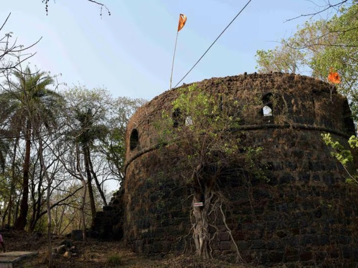
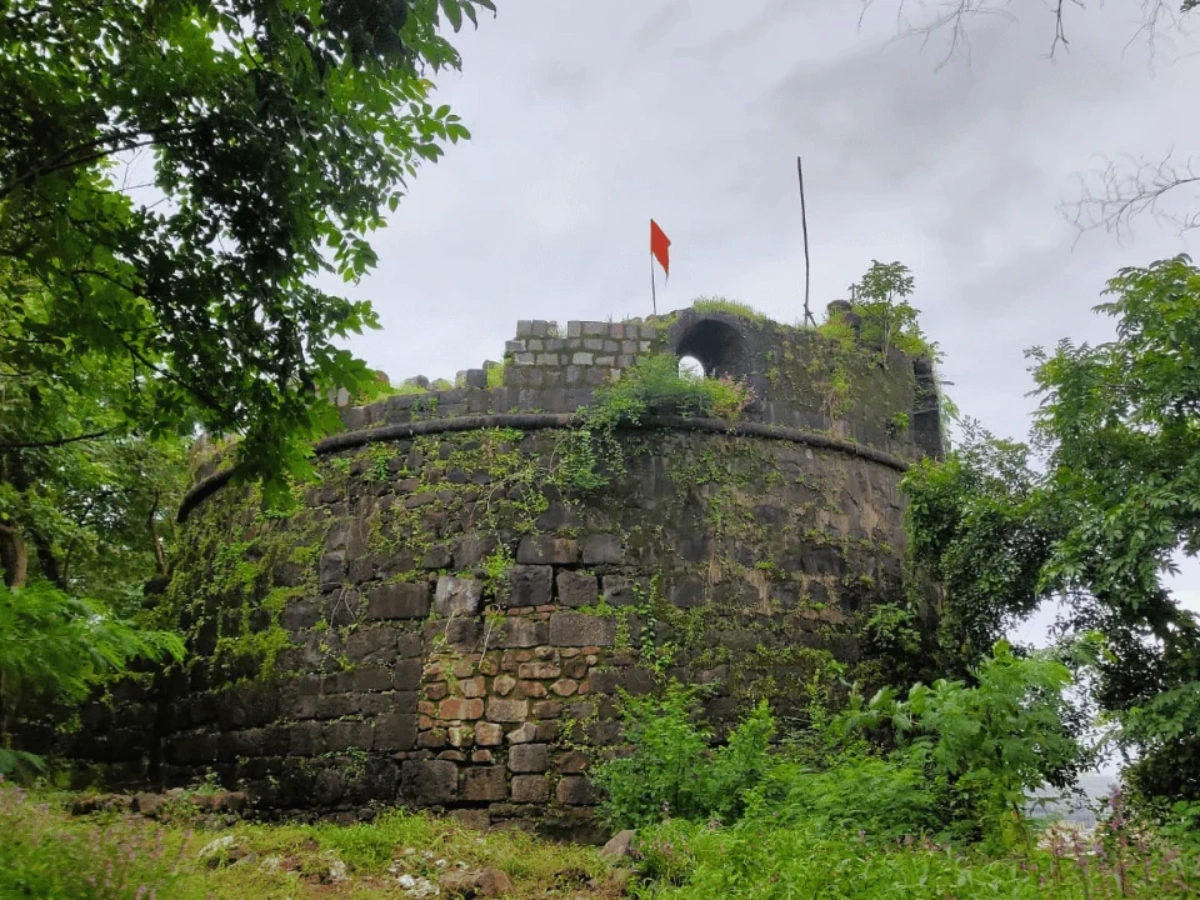
One of the most important architectural elements of Belapur Fort was its bastion system. Historical records indicate that the fort had five bastions, strategically positioned to provide maximum visual coverage and cannon firing angles. These bastions functioned as both observation points and artillery platforms, allowing defenders to attack approaching enemy vessels or land forces effectively.
The main circular bastion located at the highest point of the fort provided a complete 360-degree view of the surrounding region. From this elevated position, guards could monitor the creek, nearby villages, and inland routes, ensuring early detection of any enemy movement. This circular bastion remains the most prominent surviving structure and continues to define the fort’s visual identity today.
European Influence on Belapur Fort Architecture
When the Portuguese captured Belapur Fort in 1682, they significantly expanded and strengthened its military structure. Unlike traditional Indian forts that relied heavily on natural terrain, Portuguese fortification techniques focused on reinforced artillery positioning and structured defensive geometry. They added bastion reinforcements and converted parts of the fort into a land battery capable of supporting multiple cannons.
One of the most important additions was the northern bastion, which followed European architectural design principles. This bastion had straight edges and structured defensive positioning, unlike the rounded bastions typical of Indian forts. It was likely used as a guardhouse or command center, reflecting Portuguese military engineering expertise and their focus on artillery warfare.
Construction Materials and Structural Strength
Belapur Fort was constructed primarily using basalt stone, a volcanic rock commonly found in the Deccan region. Basalt was chosen because of its exceptional durability and resistance to environmental damage, especially in coastal areas exposed to humidity and salt. The stones were bonded using lime mortar, a traditional material known for its strength and flexibility.
This combination of basalt and lime mortar allowed the fort to withstand centuries of weathering, invasions, and structural stress. Even after partial demolition by the British and decades of neglect, many original walls and bastions remain intact, proving the effectiveness of the construction techniques used by its original builders.
Water Supply System and Hydraulic Engineering Inside the Fort
One of the most impressive engineering features of Belapur Fort was its water management system. The fort contained square-shaped masonry wells designed to store fresh water, ensuring survival during sieges or prolonged isolation. These wells were strategically constructed to access underground freshwater sources, preventing dependence on external supply routes.
One of these wells contains an inscription dating back to 1732, highlighting the fort’s operational importance during Portuguese rule. Remarkably, these wells still hold water today despite the fort’s proximity to the creek, demonstrating the advanced hydrological knowledge of the builders who carefully selected locations with access to freshwater aquifers.
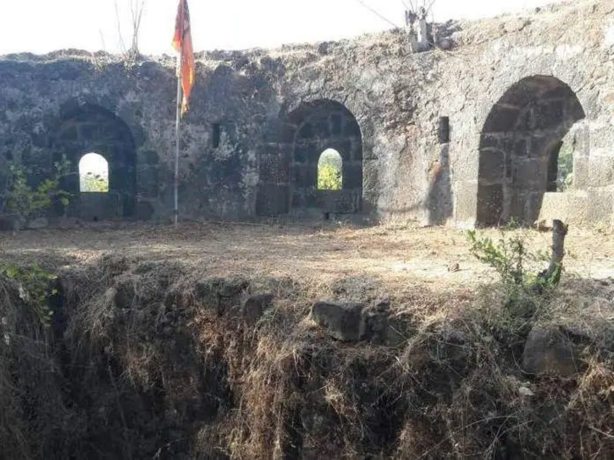
Internal Layout and Military Functional Zones
Belapur Fort was not just a defensive wall but a fully functional military installation. The internal layout included ammunition storage areas, soldier quarters, surveillance platforms, and defensive bastions. Each part of the fort was designed with a specific military purpose, ensuring efficient operation during conflict.
The lower levels of bastions were used for storage, protecting ammunition and supplies from enemy fire and weather exposure. The upper levels were used for active defense, allowing soldiers to monitor surroundings and operate cannons. This multi-level defensive structure allowed efficient military coordination within a relatively compact space.
Cannons and Artillery Power of Belapur Fort
During its peak operational period, Belapur Fort was equipped with at least 14 cannons ranging from 4-pound to 12-pound artillery guns. These cannons were positioned strategically to target ships attempting to pass through Panvel Creek or approach the fort from land. This artillery strength made the fort a powerful defensive installation despite its relatively small size.
The Portuguese maintained a garrison of approximately 720 soldiers, organized into four military companies, reflecting the fort’s importance in protecting regional maritime routes. The presence of such a large military force indicates that the fort was considered a high-priority defense point, not just a secondary outpost.
Secret Tunnel Legend and Strategic Network Connectivity
Local legends suggest that Belapur Fort was connected to Elephanta Island through an underground tunnel, allowing soldiers to escape or move secretly during attacks. While there is no archaeological evidence confirming the existence of such a tunnel, the story reflects the strategic relationship between forts across the Mumbai harbor region.
In reality, forts like Belapur, Elephanta, and Karnala formed a defensive network controlling key maritime and inland routes. Even without physical tunnels, these forts functioned as interconnected surveillance points, ensuring comprehensive protection of coastal territories. The tunnel legend symbolizes this strategic connectivity rather than representing an actual underground passage.
Portuguese Control and Transformation of Belapur Fort
In 1682, the Portuguese captured Belapur Fort as part of their larger campaign to strengthen their dominance over the Konkan coast. At that time, the Portuguese Empire controlled major coastal forts including Vasai, and they recognized the strategic importance of Belapur in protecting maritime access to their territories. Instead of destroying the fort, they reinforced its structure, added artillery defenses, and expanded its military capabilities.
The Portuguese renamed the fort Belaflor do Sabaio, meaning the Beautiful Flower of Sabaio. They stationed approximately 720 soldiers inside the fort and installed multiple cannons to defend against naval and land attacks. This transformation turned Belapur Fort into one of the most important defensive outposts protecting the southern boundary of Portuguese-controlled regions.
Maratha Capture of Belapur Fort and the Origin of Its Name
In the 18th century, the Marathas launched a major military campaign to reclaim coastal forts from Portuguese control. The campaign was led by Chimaji Appa, a highly skilled military commander and brother of Peshwa Bajirao I. Belapur Fort was captured during this campaign, marking a significant victory for the Marathas in their effort to regain control of Konkan territories.
According to historical tradition, one of the Maratha commanders, Sardar Janojirao Shinde, made a sacred vow before the battle. He promised that if the Marathas successfully captured the fort, he would offer Beli leaves to the nearby Amruthaishwar Temple as a mark of devotion. After their victory, this vow was fulfilled, and the fort was renamed Belapur, derived from the word Beli, symbolizing this religious offering and marking the beginning of its new identity.
British Capture and Partial Demolition of the Fort
Belapur Fort remained under Maratha control until the early 19th century, when the British East India Company expanded its influence across western India. In 1817, British forces led by Captain Charles Gray captured the fort during the Third Anglo-Maratha War. This marked the final military takeover of Belapur Fort and ended its role as an active defensive installation.
Unlike previous rulers, the British had no intention of using the fort for defense. Instead, they partially demolished its structure to prevent it from being used in future rebellions. Cannons were removed, defensive walls were damaged, and the fort was abandoned. Over time, nature began reclaiming the site, and the fort gradually turned into the ruins seen today.
Religious Importance of Belapur Fort and Govardhani Devi Temple
Belapur Fort is not only a military structure but also holds religious significance for local communities. Within the fort premises, there is a temple dedicated to Govardhani Devi, believed to have been established after the Maratha victory. This temple became an important spiritual site for local residents and soldiers, symbolizing divine protection and victory.
The nearby Amruthaishwar Temple also plays an important role in the fort’s cultural history. This temple is directly connected to the vow made by Maratha commander Janojirao Shinde before capturing the fort. The connection between the fort and these temples reflects how military and religious traditions were deeply intertwined during that period.
Connection Between Belapur Fort and Agri-Koli Community
The region surrounding Belapur Fort has been home to the Agri and Koli communities for centuries. These communities were the original inhabitants of the Konkan coast and played a major role in maritime activities, fishing, and navigation. Their deep knowledge of the creek system made them valuable allies for rulers controlling coastal forts like Belapur.
Even today, the fort remains an important part of their cultural identity and heritage. For local residents, the fort represents not just historical ruins but a symbol of their ancestral connection to the land. Festivals, temple visits, and local traditions continue to keep the cultural significance of Belapur Fort alive in the modern urban environment.
Strategic Role of Belapur Fort in Protecting Trade Routes
During the 16th and 17th centuries, maritime trade was the backbone of economic activity in western India. Belapur Fort played a critical role in protecting these trade routes by monitoring ships entering and exiting Panvel Creek. This creek was one of the main transportation routes connecting coastal ports with inland markets such as Pune.
By controlling Belapur Fort, rulers could regulate trade, collect taxes, and prevent enemy forces from accessing important inland territories. This made the fort a key economic and military asset, ensuring the stability and security of regional trade networks for centuries.
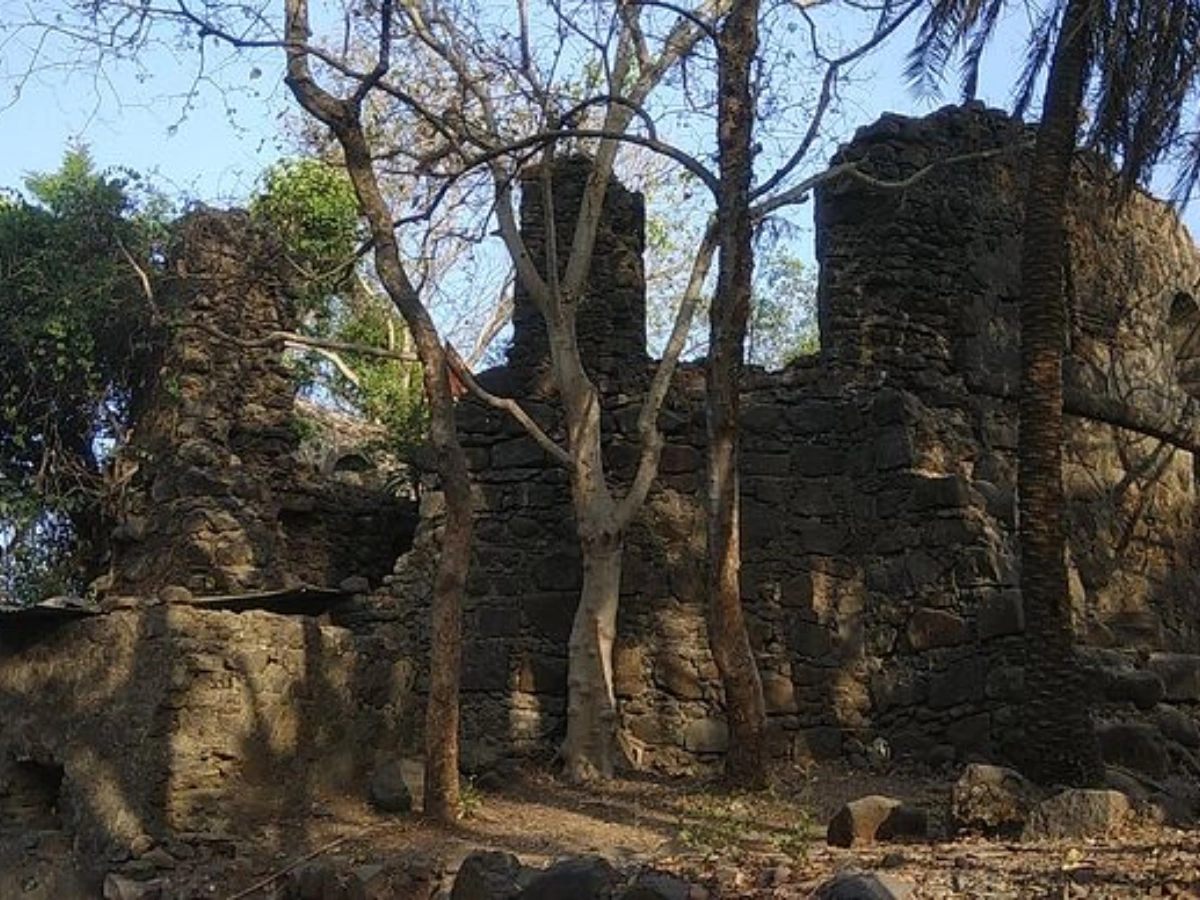
Current Condition of Belapur Fort and Its Structural Status
Today, Belapur Fort exists in a partially ruined state, with most of its original defensive walls, bastions, and internal structures damaged due to centuries of neglect and deliberate demolition during British rule. Although many parts of the fort have collapsed, key architectural elements such as bastions, water wells, and elevated platforms still survive, providing a clear idea of its original military design.
Urban development around CBD Belapur has significantly changed the fort’s surroundings, replacing marshlands and mangroves with roads, buildings, and residential complexes. Despite this transformation, the fort continues to stand on its elevated hillock, maintaining its historic dominance over the landscape and serving as a visible reminder of Navi Mumbai’s deeper historical roots.
CIDCO Restoration Efforts and Conservation Challenges
In recent decades, CIDCO became responsible for maintaining Belapur Fort as part of its role in developing Navi Mumbai. However, restoration efforts have faced criticism due to improper conservation methods, including the use of modern construction materials such as cement instead of traditional lime mortar. These methods weakened the structural integrity of certain sections instead of preserving them properly.
In 2021, part of the fort collapsed during heavy rainfall, highlighting the urgent need for professional archaeological conservation. Following public concern and expert recommendations, plans were initiated to transfer the fort’s control to the Maharashtra State Archaeology Department. This move aims to ensure scientifically accurate restoration and long-term protection of the monument.
Trekking Experience and Visitor Access to Belapur Fort
Belapur Fort has become a popular trekking destination for local residents, students, and history enthusiasts. The trek to the fort is relatively short and suitable for beginners, taking approximately 20 to 30 minutes to reach the top. The path passes through natural vegetation and rocky terrain, offering a peaceful escape from the surrounding urban environment.
Unlike remote hill forts in Maharashtra, Belapur Fort’s accessibility makes it ideal for casual visitors and weekend explorers. Its location within CBD Belapur allows easy access without requiring long-distance travel, making it one of the few historical trekking spots located inside a major planned city like Navi Mumbai.
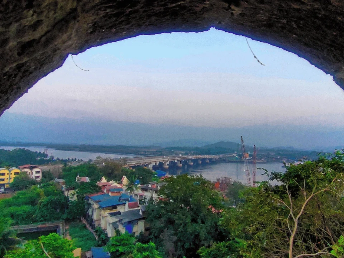
View from the Top of Belapur Fort and Visitor Experience
One of the most remarkable features of Belapur Fort is the panoramic view it offers from its highest bastion. Visitors can see Panvel Creek, nearby mangrove forests, Parsik Hills, and the modern skyline of Navi Mumbai. This contrast between ancient ruins and modern infrastructure creates a unique visual experience rarely found in urban environments.
The elevated position also allows visitors to observe the original strategic advantage of the fort. From this viewpoint, it becomes clear how soldiers could monitor ship movements and protect important trade routes. Today, this same viewpoint attracts photographers, trekkers, and visitors seeking both historical insight and scenic beauty.
Best Time to Visit Belapur Fort for Trekking and Exploration
The best time to visit Belapur Fort is between October and February, when the weather is cooler and more comfortable for trekking. During these months, the surrounding greenery is also more visible, enhancing the overall experience. Early morning and evening visits are especially popular due to pleasant temperatures and clear visibility.
During the monsoon season, the fort and surrounding hills become covered with lush vegetation, making the area visually attractive. However, visitors should exercise caution during heavy rainfall, as trekking paths can become slippery. Despite seasonal challenges, the fort remains accessible throughout the year.
Tourism Potential and Future Importance of Belapur Fort
Belapur Fort has significant potential to become one of Navi Mumbai’s major historical tourism attractions. Its central location, easy accessibility, and historical importance make it suitable for heritage tourism development. Plans have been proposed in the past to develop visitor facilities such as museums, guided tours, and educational exhibits.
Proper conservation and promotion could transform Belapur Fort into an important cultural landmark, helping residents and visitors understand the region’s historical significance. As Navi Mumbai continues to grow as a modern city, preserving sites like Belapur Fort is essential for maintaining its historical identity and cultural heritage.
Why Belapur Fort Remains One of Navi Mumbai’s Most Important Historical Landmarks
Belapur Fort represents more than just a military structure; it symbolizes the region’s transformation through multiple historical periods. From Siddi naval control to Portuguese expansion, Maratha resurgence, and British colonization, the fort has witnessed key events that shaped the political and economic landscape of western India.
Even today, the fort serves as a physical reminder that Navi Mumbai’s history did not begin with modern urban planning. Its continued existence connects the present city to its centuries-old past, making it one of the most important historical landmarks in Navi Mumbai and an essential site for cultural preservation.
How to Reach Belapur Fort – Complete Location and Transport Guide
Belapur Fort is located in Sector 32, CBD Belapur, one of the most accessible and centrally located nodes in Navi Mumbai. The nearest railway station is CBD Belapur on the Harbour Line, which connects directly to major areas like Vashi, Nerul, and Mumbai CST. From the station, the fort can be reached within 10 to 15 minutes by auto-rickshaw or private vehicle.
The fort is also easily accessible by road through Palm Beach Road and Sion-Panvel Highway, making it convenient for visitors traveling from Mumbai, Panvel, or other parts of Navi Mumbai. Due to its central urban location, Belapur Fort remains one of the most accessible historical forts in Maharashtra, unlike remote hill forts that require long-distance travel.
Comparison of Belapur Fort with Other Forts in Navi Mumbai Region
Belapur Fort differs significantly from other forts in the Navi Mumbai and Konkan region due to its urban location and creek-based strategic role. While forts like Karnala Fort were designed to control mountain passes and inland routes, Belapur Fort was specifically built to monitor maritime trade and creek transportation routes. This makes it a unique example of a coastal surveillance fort.
Unlike large hill forts that required hours of trekking, Belapur Fort was designed for quick military access and efficient surveillance. Its compact size, elevated position, and proximity to important waterways made it highly effective despite its smaller structure, demonstrating how military architecture was adapted based on geographic and strategic needs.
Hidden Historical Facts About Belapur Fort Most People Don’t Know
One of the most surprising facts about Belapur Fort is that it originally stood on an island surrounded by marshlands and tidal creeks. Over centuries, land reclamation and urban development connected the fort to the mainland, changing its geographic isolation. Despite these changes, the fort’s elevated hill structure preserved its original surveillance advantage.
Another lesser-known fact is that the fort once housed over 700 soldiers and multiple artillery cannons, making it a major military installation rather than a small defensive outpost. This highlights the importance of Belapur Fort in controlling regional maritime routes and protecting trade networks during its operational period.
Conclusion
Belapur Fort stands as one of the oldest surviving historical structures in Navi Mumbai, representing over 450 years of military, cultural, and architectural history. Its strategic location, strong defensive design, and role in controlling maritime trade routes made it an essential part of regional power dynamics for centuries.
Today, the fort serves as a powerful reminder that Navi Mumbai’s history extends far beyond modern urban development. Preserving and promoting Belapur Fort is essential for protecting the city’s cultural identity and ensuring that future generations remain connected to its historical legacy.
FAQs
Frequently Asked Questions