Kamothe Navi Mumbai: Secret History
Kamothe Navi Mumbai is one of the well-planned areas by CIDCO, It is also situated at the ideal location, the Sion-Panvel Highway and Mumbai-Pune Expressway are located nearby hence the connectivity is excellent. Cheap housing, shopping centers, the existence of half a dozen local industries make the location prosperous The surrounding industrial zones and the proposed Navi Mumbai International Airport and the upcoming metro system will give the location economic advantage. Kamothe Navi Mumbai has got good infrastructure, schools, hospitals, and commercial areas; making it a favorite residential and business point and, therefore, a major site of Navi Mumbai.
History
The transformation of a sleepy little village of 200 families to a busy urban area, Kamothe Navi Mumbai tells us nothing other but how fast Navi Mumbai has grown. Although it had a negligible population of hardly 900 during pre-independent era, presently, the masterplan of CIDCO has settled a fabric of 38 segments which has re-awakened this then-sleepy-village.
The planned node of Kamothe is relatively new and is situated in Raigad district of Maharashtra that developed in the 1990s by CIDCO (City and Industrial Development Corporation). But before it was urbanized the area had a traditional and agricultural past that was associated with the Maharashtrian village life. This is a description of how the place once could be 100 years ago
British History
Under the British rule, the Kamothe Navi Mumbai today was a part and parcel of the Bombay Presidency, an important administrative territory within the British Empire. Kamothe itself was a rural and agrarian village, with little first hand appearance in British sources and its history is tied to the larger trends in the area. The following is a brief description of context of Kamothe Navi Mumbai in the British era:
- Agriculture: The Kamothe Navi Mumbai and its surrounding region was mostly agricultural region and the cultivated produce mainly included rice, millets, pulses. Farmers used to cultivate under the conventional rural agricultural practices and depended on rainfall as well.
- Taxation: The British levied heavy land taxes in the Ryotwari system that in most occasions affected the local farming population.
- Salt Production: Salt production was another significant production in the coast by Navi Mumbai during British rule. The Salt Taxing and monopolizing of salt was enacted in the Salt Acts, although indirectly residents were affected of Kamothe Navi Mumbai, particularly when demonstrations such as the Salt Satyagraha (1930) took place.
- Railways: The British came up with railways in the region but the Panvel region (nearer to Kamothe Navi Mumbai) was more connected since that was a transit point. Even Kamothe Navi Mumbai was a lonely place, just by minor routes and the local waters.
- Trade: The economy of Kamothe was indirectly affected by the trade interests that the British had in Bombay (Mumbai).
Geography
Kamothe Navi Mumbai is one of the nodes of Navi Mumbai, located in the Raigad district of Maharashtra. It is a planned township developed by CIDCO (City and Industrial Development Corporation) and is situated in a strategic location within Navi Mumbai.
Location
Coordinates: Kamothe Navi Mumbai is situated approximately at 19.0148° N latitude and 73.0956° E longitude.
Boundaries:
- North: It is bordered by Kharghar and Taloja.
- East: The Panvel region lies to its east.
- South: It is close to Kalamboli, an industrial and residential area.
- West: Kamothe is near the Sion-Panvel Highway, providing easy connectivity to Mumbai.
Topography
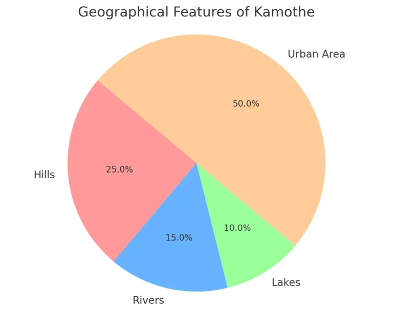
Region: The area is covered by flat plains with low hills, which are the leftovers of the western ghats.
Height above sea level: Kamothe Navi Mumbai stands at an altitude of 11 meters (36 feet) above sea level.
Topography: It is a rocky land and the soil in the region is hard laterite soil, typifying Konkan region.
Water Bodies
Panvel Creek: Located to the east, this creek is part of the larger Thane Creek system, influencing Kamothe Navi Mumbai’s ecosystem.
Ponds and Lakes: The node has a few artificial and natural water bodies used for local irrigation and domestic purposes.
Wetlands: The area historically had mangroves and wetlands, but many have been affected by urbanization.
Soil and Vegetation
Kamothe soil is mainly lateritic and alluvial, ideal for rice cultivation, though much has been altered by construction. Before urbanization, the area had abundant mangroves, shrubs, and grasses typical of coastal ecosystems. Urbanization has reduced natural vegetation, replacing it with landscaped green spaces.
Special features
Kamothe Navi Mumbai features 48 well-defined sectors, promoting a spacious and organized environment. The area boasts excellent infrastructure and has experienced rapid population growth in recent years.
Demographic
The population of Kamothe Mansarovar / Khandeshwar in 2021 was 250,000. Kamothe Navi Mumbai is a developing locality in Navi Mumbai, Maharashtra. Kamothe Navi Mumbai, is a rapidly developing suburb with a diverse population, modern infrastructure, affordable housing, and growing connectivity.
Climate
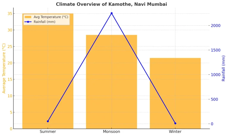
Kamothe Navi Mumbai, has a tropical monsoon climate. Summers (March-June) are hot and humid, with temperatures of 30°C-40°C and occasional pre-monsoon showers. Monsoons (June-September) bring heavy rainfall (2,000-2,500 mm) and cooler temperatures (25°C-32°C) but may cause waterlogging. Winters (October-February) are pleasant, with temperatures of 15°C-28°C, low humidity, and dry weather, ideal for outdoor activities. Humidity persists year-round due to its coastal location, with winters being the most comfortable.
Education Institution
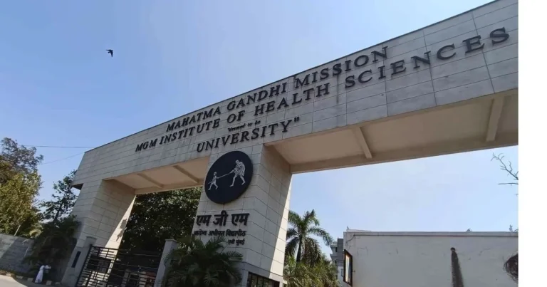
Kamothe hosts educational institutions like MNR School, K.P. C English High School, MGM Medical College, and multiple preschools.
Schools and College
Schools
1.MNR School – A well-known school providing quality education from the primary to secondary level.
2. Loknete Ramsheth Thakur Public School-LRTPS strives for excellence, nurturing students to excel academically and in various activities, develop strong intellect, and become responsible citizens.
3. Maji Amdar Dattusheth Patil Vidyalay–
Maji Amdar Dattusheth Patil Vidyalay is a school located in Kamothe Navi Mumbai. It is known for providing quality education and serving the local community.
College
1. MGM College of Engineering and Technology – Offers various undergraduate and postgraduate courses in engineering and technology.
2. Sushma Patil Vidyalaya and Junior College – Sushma Patil Vidyalaya and Junior College in Kamothe offers education from primary to junior college, with courses in science, arts, and commerce.
3. DSP College – DSP College in Kamothe Navi Mumbai, offers undergraduate and postgraduate courses in arts, commerce, and science, with a focus on academic excellence and student development.
Economy
Kamothe economy thrives on real estate, retail, and small businesses, benefiting from its strategic location in Navi Mumbai. Residential developments dominate, while growing commercial spaces support local jobs. Retail stores and service businesses cater to daily needs, and proximity to industrial hubs like Taloja and IT parks boosts economic activity. Improved infrastructure and connectivity to Mumbai and Pune further enhance investment opportunities, driving Kamothe’s economic growth.
Landmark
1. Kamothe Market Area
Kamothe itself boasts a bustling local market area where residents can shop for fresh produce, groceries, clothing, and daily essentials. The market reflects the vibrant community life in the area.
2. Proximity to Major Highways
Kamothe’s location near the Sion-Panvel Highway and Mumbai-Pune Expressway is a landmark in itself, providing excellent connectivity to Mumbai, Pune, and other parts of Navi Mumbai.
3.Shiv Mandir (Temple)
This temple is a spiritual and cultural center in Kamothe, attracting devotees and visitors seeking peace and blessings. It is known for its serene ambiance.
4.Kamothe Police Station
Located centrally, the Kamothe Police Station ensures safety and security for residents. Its presence enhances the area’s law and order situation.
5.MGM Hospital and Medical College
A significant healthcare and educational institution in the region, MGM Hospital provides high-quality medical services, while its medical college attracts students from across India.
Transport
Road Connectivity
Kamothe enjoys excellent road connectivity due to its location near the Mumbai-Pune Expressway and the Sion-Panvel Highway. These roads make it a crucial transit point for travelers heading to Mumbai, Pune, or other parts of Maharashtra.
Mumbai-Pune Expressway: Kamothe is directly accessible from this major highway, ensuring a smooth drive for long-distance travelers.
Sion-Panvel Highway: This arterial road connects Kamothe to key parts of Mumbai, such as Chembur, Sion, and Dadar.
Local roads within Kamothe are well-maintained, connecting the various sectors of this node and ensuring a hassle-free commute within the locality.
Public Transport
Kamothe offers a variety of public transport options for daily commuters:
Buses: Navi Mumbai Municipal Transport (NMMT) and Brihanmumbai Electric Supply and Transport (BEST) buses serve Kamothe, connecting it to Mumbai, Panvel, Kharghar, Vashi, and other nearby areas. Buses are a cost-effective mode of transportation for residents.
Auto-Rickshaws: Autos are the most common mode of local transport in Kamothe, offering quick and convenient travel for short distances.
Taxis: App-based taxi services like Ola and Uber are widely available, providing a comfortable and hassle-free option for commuting.
Railway Connectivity
Kamothe is located close to key railway stations that form part of the Mumbai Suburban Railway network, making it highly accessible to commuters:
Mansarovar Railway Station: The nearest station for Kamothe residents, part of the Harbour Line, connects Kamothe to Mumbai, Thane, and Navi Mumbai.
Panvel Junction: Just a few kilometers away, Panvel is a major hub in the Central Railway network, offering connections to Pune, Karjat, and other destinations. It also serves as a starting point for several long-distance trains.
Trains on the Harbour Line and Trans-Harbour Line ensure Kamothe residents can easily travel to major commercial hubs like Vashi, CST (Chhatrapati Shivaji Maharaj Terminus), and Thane.
Upcoming Infrastructure Projects
Kamothe transport infrastructure is set for major upgrades with key projects underway. The Navi Mumbai Metro Phase 1 will improve connectivity between Belapur, Kharghar, and Taloja. The Mumbai Trans Harbour Link will connect Navi Mumbai to South Mumbai, reducing travel time. The upcoming Navi Mumbai International Airport near Panvel will boost economic and real estate growth in Kamothe.
Private Vehicles
Owning a private vehicle is common in Kamothe due to its well-developed road network. The locality has ample parking facilities, and the wide roads ensure minimal traffic congestion compared to other parts of Mumbai
Intercity Travel
For intercity travel, Kamothe residents benefit from nearby facilities:
Panvel Bus Depot: Provides buses to Pune, Kolhapur, Nagpur, and other parts of Maharashtra.
Long-Distance Trains: Panvel Junction offers long-distance train services to Goa, Karnataka, and South India.
Future Prospects
The ongoing and planned infrastructure projects promise to transform Kamothe into a well-connected and accessible locality. Enhanced metro and airport connectivity will further solidify its position as a sought-after residential hub.
In summary, Kamothe’s transport system is a mix of well-established road and rail networks, complemented by the promise of future developments. Its proximity to major highways and the upcoming international airport ensures that residents and businesses in Kamothe will continue to enjoy excellent connectivity.
Areas of Kamothe
1. Residential Sectors (1-22)
Kamothe is broadly divided into 22 sectors, each offering a mix of residential, commercial, and recreational spaces.
Key Features:
Sector 1 to 9 (East Kamothe):
Predominantly residential with affordable housing options.
Proximity to Khandeshwar railway station.
Green spaces and parks, suitable for families.
Educational institutions and healthcare facilities nearby.
Sector 10 to 16 (Central Kamothe):
A mix of mid-range and premium apartments.
Closer to major markets, retail outlets, and restaurants.
Good road connectivity to Mumbai-Pune Expressway.
CIDCO’s well-maintained infrastructure, including wide roads and drainage systems.
Sector 17 to 22 (West Kamothe):
Recently developed sectors with modern residential complexes.
Proximity to the proposed Navi Mumbai International Airport.
Quiet and less congested compared to the central sectors.
Upcoming commercial hubs and IT spaces.
2. Key Landmarks and Facilities
Khandeshwar Railway Station:
Located centrally, connecting Kamothe to major parts of Navi Mumbai and Mumbai.
Serves as a lifeline for daily commuters.
Parks and Recreation:
CIDCO Garden in various sectors, ideal for jogging and leisure.
Proximity to Panvel Creek offers scenic spots for relaxation.
Healthcare Facilities:
Hospitals like MGM Hospital and Matoshree Multispecialty Hospital provide quality medical care.
Conclusion
Kamothe, with its strategic location, modern infrastructure, and growing economy, offers a balanced lifestyle for residents. Its educational institutions, healthcare facilities, and connectivity make it an attractive destination for homebuyers, businesses, and investors, ensuring continuous development and prosperity.
FAQ's
Frequently Asked Questions