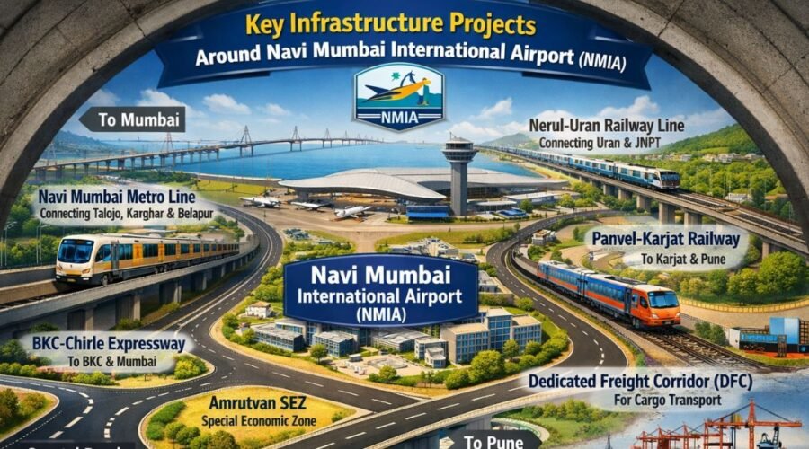
Key Infrastructure Projects Around Navi Mumbai International Airport (NMIA)
Navi Mumbai International Airport is not just a transport upgrade. It is a structural shift. For the first time since Navi Mumbai was conceived, infrastructure is not reacting to population growth. It is leading it. NMIA is changing how the city expands, how people commute, and how real estate value is understood.
Until now, Navi Mumbai developed in fragments. Residential sectors were occupied first, and connectivity followed later. With NMIA, that sequence is reversed. Roads, metro corridors, railway upgrades, and commercial zones are being aligned first, with the airport acting as the central reference point. This is why NMIA is repeatedly described as a growth anchor rather than a standalone project.
This map tour is designed to explain that alignment. Not just where NMIA is located, but how connectivity, distance, and future value overlap around it. When those three factors come together, infrastructure stops being theoretical and starts becoming predictable.
Understanding NMIA’s Strategic Location
The Panvel–Ulwe belt was selected because it offers something rare in the Mumbai Metropolitan Region. Balance. It sits between Mumbai city to the west, Navi Mumbai’s established nodes to the north, and the Raigad district to the south and east. This positioning allows movement from multiple directions without forcing all traffic into one congested corridor.
Land availability was a decisive factor. Airports require long-term flexibility. Additional terminals, cargo facilities, maintenance zones, and safety buffers cannot be added as afterthoughts. The Panvel–Ulwe region provided large, contiguous land parcels capable of supporting not only the current airport phase but future expansions as well. This single advantage separates NMIA from Mumbai’s existing airport, which has been spatially constrained for decades.
Proximity strengthens this logic further. Ulwe lies just a few kilometres from NMIA. Panvel sits within a short driving radius. Kharghar and Taloja fall comfortably within daily commuting distance. South Mumbai, via MTHL, becomes reachable in under an hour during off-peak hours. NMIA compresses geography, and compressed geography changes behaviour.
Regional Connectivity Advantage

On a regional map, NMIA functions less like a destination and more like a connector. Mumbai city lies to the west. Navi Mumbai’s residential and commercial nodes extend northward. JNPT and the logistics-industrial belt sit to the south and east. NMIA sits at the centre of this triangle.
Passenger movement flows in from Mumbai and Navi Mumbai. Cargo movement aligns naturally with JNPT. The airport workforce travels daily from Panvel, Ulwe, Kharghar, Taloja, and even Raigad. This multi-directional connectivity reduces dependency on a single route and distributes pressure across multiple networks.
That distribution is critical. Infrastructure fails when everything depends on one corridor. NMIA avoids that risk by design.
Road Infrastructure Around NMIA and MTHL Connectivity
The Mumbai Trans Harbour Link has fundamentally changed how NMIA connects to the city. South Mumbai, once perceived as distant from Navi Mumbai, is now directly accessible. For airport operations, this means predictable travel times for business travellers, logistics operators, and aviation staff.
MTHL also plays a strategic role beyond speed. It creates redundancy. Airport access does not collapse when one route is congested. At the same time, it shifts development pressure eastward, easing stress on older suburban corridors.
National highways reinforce this structure. NH 348 provides direct connectivity between NMIA and JNPT, supporting freight and cargo movement. NH 4B strengthens industrial access across Raigad and Navi Mumbai. Internal CIDCO roads connect Panvel and Ulwe through planned grids rather than organic bottlenecks. Together, these roads separate passenger and freight movement, which improves efficiency and safety.
Upcoming access roads around NMIA are designed to manage future traffic volumes. Their goal is prevention rather than reaction. To distribute traffic early and protect residential zones from spillover congestion.
Metro Connectivity to NMIA and Daily Commute Impact
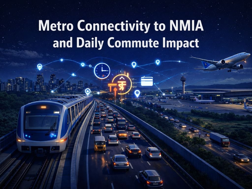
The Navi Mumbai Metro gains strategic importance once NMIA is factored in. Existing operational stretches already support residential and commercial movement across key nodes, creating a base network.
Planned metro extensions are aligned with airport terminals, not added later. This matters. Direct metro access allows large-scale workforce movement without overwhelming roads. Over time, it also changes how people choose where to live.
Residential demand begins clustering around metro stations. Office locations follow predictable transit routes. This shift quietly influences real estate prices and density patterns across Ulwe, Kharghar, and adjoining areas.
Railway Network Supporting NMIA
| Node | Distance from NMIA (Approx) | Connectivity Mode |
|---|---|---|
| Ulwe | 2 – 5 KM | Road / Proposed Metro |
| Panvel | 5 – 8 KM | Rail / Road / Metro |
| Kharghar | 12 – 15 KM | Metro / Sion–Panvel Highway |
| South Mumbai | 25 – 30 KM | MTHL (Atal Setu) |
Key Navi Mumbai Nodes Influenced by NMIA
Ulwe benefits most directly due to proximity and planning structure. With CIDCO-led sectors and wide road networks, airport influence has already translated into visible residential demand.
Panvel functions as the region’s transport and transit core. Road, rail, metro, and airport connectivity intersect here, making it a natural hub for trade, hospitality, logistics, and housing.
Kharghar and Taloja offer balance. Kharghar provides established residential and educational infrastructure. Taloja supports industrial employment and relatively affordable housing. Together, they support the airport ecosystem without overconcentration. Dronagiri, influenced by JNPT, represents the logistics and industrial extension of this system. NMIA strengthens its strategic relevance.
Real Estate Impact and Investment Perspective

From an investment standpoint, Ulwe currently shows the strongest airport-driven momentum due to proximity and confirmed infrastructure. Panvel offers long-term stability through multi-modal connectivity. Kharghar remains attractive for end-users due to social infrastructure, while Taloja provides affordability for workforce housing.
Expected commercial operations for NMIA are targeted around 2025, with phased expansion thereafter. Historically, real estate markets price in such infrastructure well before full operation, which explains rising demand across connected nodes.
Conclusion
NMIA is not an isolated airport project. It is the infrastructure spine shaping Navi Mumbai’s next 20 to 30 years. Roads, metro lines, railway corridors, residential nodes, and economic zones all align around it.
Areas connected to this spine will mature steadily. Areas outside it will struggle to keep pace. Understanding this map today is not about speculation. It is about reading how the city is being structured in real time.
If you are evaluating connectivity to NMIA, real estate near NMIA, or long-term investment potential around MTHL and Navi Mumbai’s growth corridors, this map is not optional. It is essential.
FAQ's
Frequently Asked Questions