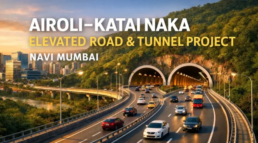
Airoli Katai Naka Elevated Road: Route, Status & Updates
Why This Road Matters More Than It Looks
If you’ve ever lived in the triangle between Navi Mumbai, Thane, and Kalyan, you know that geography isn’t just a subject in school-it’s a daily tax on your sanity. I remember sitting in my car near Mahape about two years ago. The sun was setting, painting the sky a beautiful orange, but all I could focus on was the brake lights of a thousand trucks ahead of me. I was trying to get to a friend’s house in Dombivli for dinner. Google Maps, in its infinite and cold wisdom, told me I was twenty minutes away. Forty-five minutes later, I hadn’t moved a kilometer. That is the “Parsik Penalty.”
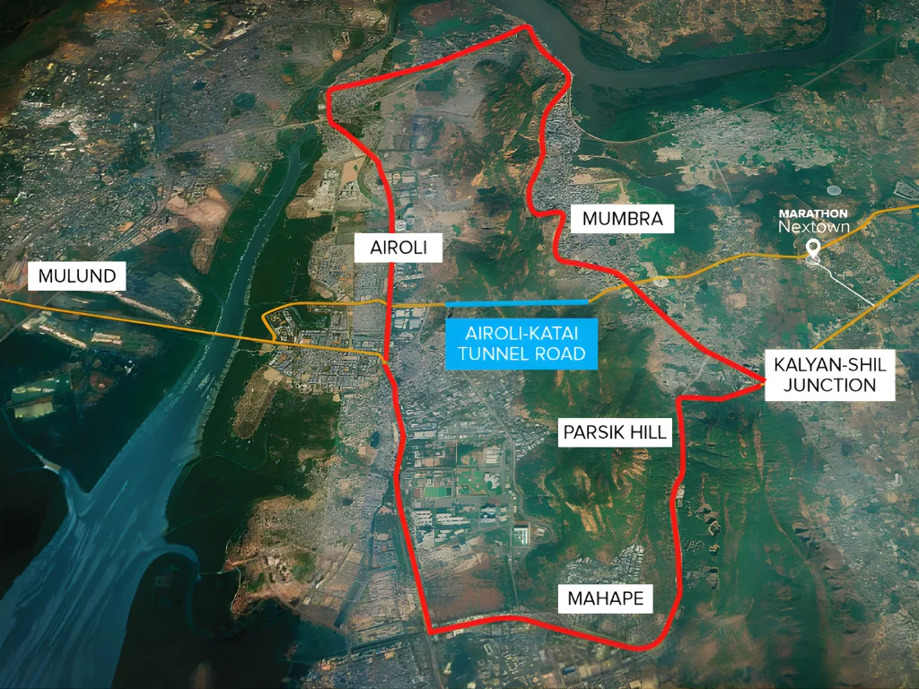
For decades, the Parsik Hill range has stood like a silent, stony wall between the glass-and-steel IT hubs of Airoli and the sprawling residential heartlands of the Kalyan-Shil belt. You either went around it through the crumbling, narrow roads of Mumbra, or you fought the industrial chaos of the Mahape-Shilphata road. There was no middle ground. But today, as I look at the massive drilling rigs and the rising pillars of the Airoli-Katai Naka Elevated Road, it feels like the city is finally standing up for itself. This isn’t just a road project; it’s a structural correction of a historical mistake.
The Geography Problem: Why a Tunnel Was the Only Answer
Why did it take us so long to realize that we couldn’t just keep widening surface roads? Every time we added a lane to the Shilphata road, three more trucks appeared to fill it. The Mumbai Metropolitan Region (MMR) hit a hard physical limit. On one side, you have the Thane creek and the industrial belt; on the other, the rising slopes of the Parsik Hills. Planners eventually realized that the only way to connect the “Office” (Navi Mumbai) with the “Home” (Kalyan-Dombivli) was to go straight through the rock.
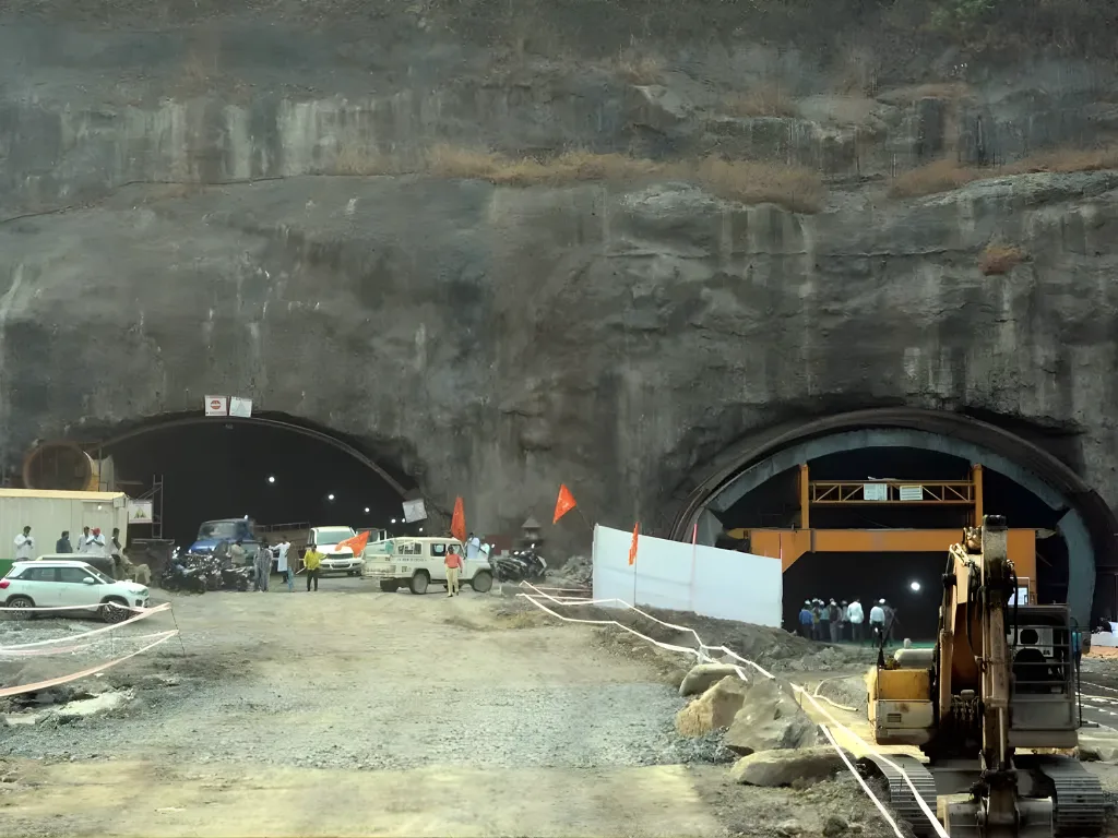
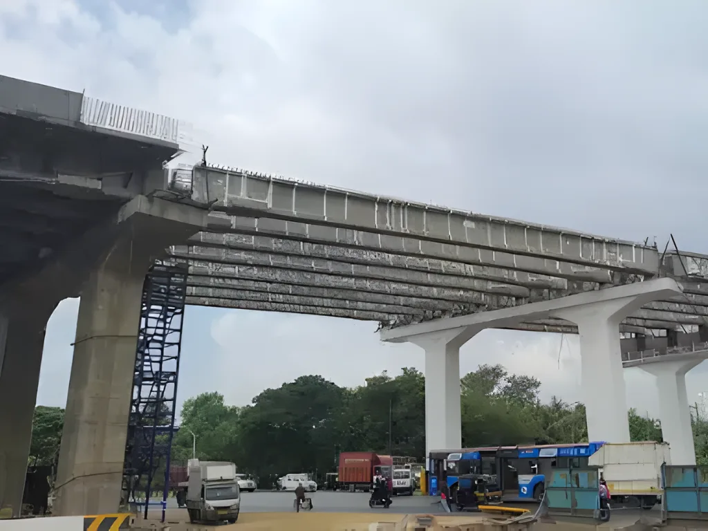
The centerpiece of this project is the 1.69-kilometer twin-tube tunnel. It’s an engineering marvel that feels almost futuristic when you see the scale of it. Most of the tunnels we are used to in India are dark, cramped, and feel a bit claustrophobic. This one is being built with three lanes plus a dedicated emergency lane in each tube. As of early 2026, the civil work is nearly done. They are currently installing the high-tech ventilation systems and fire suppression units. When you drive through it for the first time-likely in late 2026-you’ll realize that those seven kilometers of “missing link” were the only thing keeping this region from exploding with potential.
Breaking Down the Phases: When Do We Actually Get to Drive?
I get a lot of questions about the timeline. People see the pillars and ask, “Why isn’t it open yet?” Infrastructure is a slow dance with gravity and bureaucracy. The MMRDA split this into three phases, and understanding them is key to managing your expectations.
Phase 1 & 2: The Direct Connection
This is the part that most of us are waiting for. It includes the tunnel and the elevated section starting from the Mulund-Airoli Bridge side. By mid-to-late 2026, this section is expected to be operational. This means you can bypass the Airoli Naka signal, skip the Mahape congestion, dive into the tunnel, and pop out near the Mumbra NH-4 bypass. Even if the rest of the road isn’t ready, this alone saves about 25 minutes of crawling through local traffic.
Phase 3: The Long Stretch to Katai
This is where the real patience comes in. This 6.5-kilometer elevated stretch from Mumbra to Katai Naka is complex. It crosses salt pans, sensitive mangrove zones, and the busy railway tracks near Diva. Because of the environmental clearances and the sheer difficulty of building over live railway lines, this section has a target of late 2028. Is it a long wait? Yes. But considering we’ve waited thirty years for a solution, another two years for the “full signal-free experience” feels like a price worth paying.
The Real Estate Shift: The Silent Repricing of the East
Markets move much faster than cement mixers. If you look at the property rates in the Kalyan-Shil belt over the last eighteen months, you’ll see a steady climb. Investors aren’t waiting for the ribbon-cutting ceremony; they are buying in now because they know what happens to a suburb when it suddenly becomes “20 minutes from the office.”
Historically, Dombivli East was where you went if you wanted a bigger house but couldn’t afford the commute. Now, it’s becoming a choice for the affluent IT crowd. When I talk to real estate agents in the area, they tell me that the “tenant profile” is changing. We are seeing more people who work in Mindspace Airoli or Reliable Tech Park looking for homes in the Shil-Palava belt. They are happy to pay a bit more for a gated community because they know the commute won’t kill them anymore.
Genuine Price Rates (Early 2026 Estimates):
| Project Name | Location / Node | Segment | Status |
|---|---|---|---|
| Sai Radiance | CBD Belapur | Residential | Completed |
| Ratna Enclave | Roadpali | Residential | Completed |
| The Springs | Roadpali | Mid-segment residential | Completed |
| The Springs 2 | Roadpali | Mid-segment residential | Completed |
| Platinum Springs | Taloja | Early-entry residential | Completed |
| Akshar Shreeji Heights | Seawoods | Residential | Completed |
| Shreeji Orlem World | Malad West, Mumbai | Redevelopment township | Completed |
| Shreeji Castle | Ulwe | Residential | Completed |
Available Shops and Landmarks in the Vicinity:
The area around Katai Naka and the Kalyan-Shil road has transformed from a barren stretch into a retail hub.
- Xperia Mall: The crown jewel of the Palava-Shil stretch. It has everything from H&M and Marks & Spencer to a PVR cinema.
- D-Mart (Kalyan-Shil Road): Always packed, this is the lifeline for the thousands of families in the new townships.
- Metro Wholesale: A massive outlet near Kalyan that serves as the backbone for local businesses and bulk shoppers.
- Big Bazaar (now Smart Bazaar): Located within the major township clusters.
- Lodha World School and Pawar Public School: These institutions have turned this into a proper family-friendly residential zone.
The Toll Reality: A Necessary Evil?
Let’s talk about the elephant in the room: the toll. Yes, this road will be a toll-based facility. The MMRDA needs to recover the thousands of crores spent on drilling through that mountain. While the final notification isn’t out, we expect the toll for cars to be in the range of ₹60 to ₹85 for a one-way trip.
I hear a lot of grumbling about this. “Why should we pay to drive in our own city?” But here’s my personal take: Think about the fuel. If your car idles in Mumbra traffic for 40 minutes, you are burning at least 1.5 to 2 liters of petrol. At current prices, that’s almost ₹200 literally gone up in smoke. Paying ₹70 to bypass that chaos isn’t an expense; it’s a savings. Not to mention the wear and tear on your car’s clutch and your own mental health. In a city like Mumbai, we don’t pay tolls for the road; we pay for the minutes we get back with our families.
The "Super-Grid" Effect: More Than Just a Road
We often look at these projects in isolation, but the Airoli-Katai road is part of a much larger “Super-Grid.” It’s designed to plug into the future Virar-Alibaug Multimodal Corridor and the various elevated roads planned around Bhiwandi. This means that eventually, you won’t just be going from Airoli to Katai; you’ll be able to bypass the entire congested core of the MMR.
This is also why I believe this road is more important than the Metro for this specific region. The Metro is great for students and individual office-goers. But what about the thousands of small businesses in Kalyan? What about the logistics companies that move goods from the JNPT port to the warehouses in Bhiwandi? What about an ambulance trying to get a patient from a Dombivli clinic to a specialized hospital in Vashi? They need roads. They need a high-speed spine that can handle heavy wheels. This corridor provides that.
Environmental Stewardship: Balancing Growth and Nature
I want to spend a moment on the environmental aspect. You can’t build a 12-kilometer road through hills and salt pans without an impact. The project faced significant delays because of the mangrove patches near Diva. I think it’s a good sign that the authorities didn’t just bulldoze through. They had to wait for Central-level clearances and commit to compensatory afforestation.
The paradox of urban infrastructure is that building a road can sometimes be the “greener” option in the long run. When 50,000 vehicles stop idling in traffic and start moving at a steady 80 km/h, the total emission profile of the region actually improves. We aren’t just moving cars; we are optimizing the flow of a city that was previously choking on its own fumes.
What Changes for You?
At the end of the day, we don’t care about the grade of concrete or the diameter of the tunnel boring machine. We care about whether we can make it home in time to see our kids before they sleep. We care about not being exhausted before the workday even begins.
I remember a conversation with a taxi driver who lives in Kalyan and works in Navi Mumbai. He told me he spends almost 5 hours a day just driving to and from his “starting point.” For him, this road isn’t just infrastructure. It’s a life-saver. It’s two extra hours of sleep. It’s less money spent on medicine for back pain. That is the true value of the Airoli-Katai Naka Elevated Road.
As we move toward the partial opening in 2026, I encourage everyone to look at the bigger picture. Yes, the construction is a mess right now. Yes, the dust is annoying. But we are witnessing the birth of a new connectivity spine. Five years from now, people will move to Dombivli or Kalyan and think, “Wait, was it ever difficult to get to Airoli?” They will take this road for granted. And that will be the ultimate proof that the project succeeded. Infrastructure is at its best when it becomes invisible-when it works so well that you forget it’s even there. The Airoli-Katai road is on its way to becoming that invisible hero of our daily lives.
FAQ's
Frequently Asked Questions