
Kopar Khairane Lake | Koparkhairane Gaon Holding Pond Sector 19A
Have you ever stood by a body of water and felt like it was breathing with the city? If you’ve spent any time in Navi Mumbai, you know that our “planned” nodes can sometimes feel a bit too much like a gridefficient, yes, but occasionally lacking a soul. That changes the moment you step into the Gaothan belt of Sector 19A. Here, tucked away from the frantic honking of the Thane-Belapur Road, lies the Koparkhairane Lake.
But here’s the thing: it isn’t just a “lake” in the way a postcard describes one. It doesn’t have the manicured, touristy energy of Vashi’s Mini Seashore, nor the sprawling grandeur of the Jewel of Navi Mumbai in Nerul. Instead, Koparkhairane Lake is a hardworking, salt-of-the-earth waterbody. It’s a silent guardian that smells of the sea, echoes with the calls of pond herons, and quite literally keeps the surrounding homes from sinking during a July cloudburst.
Where is Koparkhairane Lake Located?

Maps will tell you coordinates, but let me tell you where it actually feels like it is. The Koparkhairne Gaon Holding Pond is situated in Sector 19A, tucked away at the eastern edge of the node. It’s the buffer zone.
It sits right between the dense, buzzing lanes of the Koparkhairne Gaothan (the original village settlement) and the newer, planned CIDCO layouts. If you look straight out, you see the thick green belt of mangroves that eventually leads into the Thane Creek. This placement is strategic, not accidental. It was designed to catch water before it catches us.
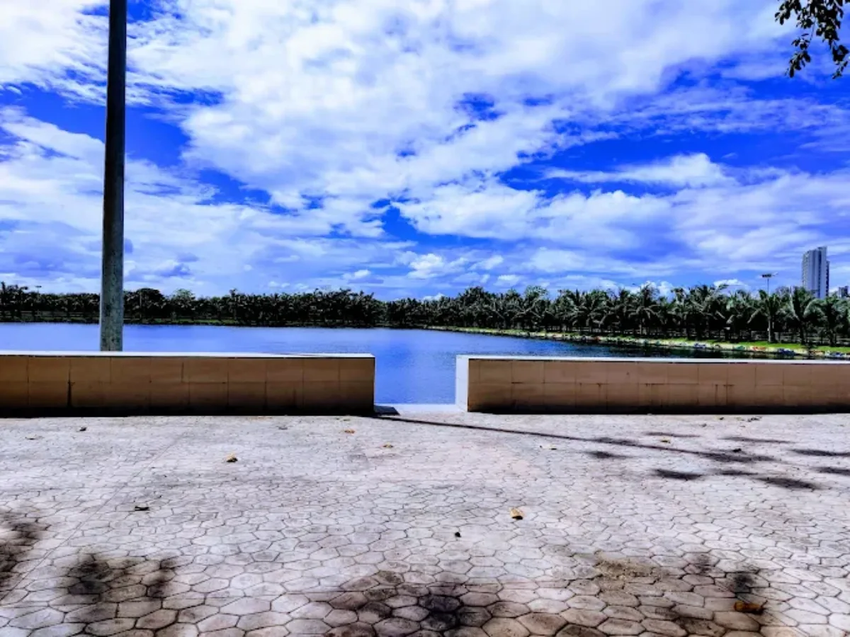
Koparkhairane Lake location is in Sector 19A, within the Gaothan belt of Kopar Khairane, Navi Mumbai. It is positioned between residential CIDCO societies and the mangrove edge that connects toward Thane Creek. The lake is officially a detention basin in the city’s stormwater management network.
For those searching for a lake near Koparkhairane Station or a Navi Mumbai lake near Sector 19, this is the primary waterbody serving that zone. Its placement is not decorative but strategic, designed to protect low-lying residential clusters.
Exact Location and Sector Details
The lake lies inside Sector 19A, close to the old village houses of Koparkhairane Gaon. It is accessible via internal roads and is surrounded by cooperative housing societies and Gaothan residences. The waterbody connects to Thane Creek through a controlled sluice gate system.
Because construction inside the lake zone is restricted, it creates a permanent open buffer in an otherwise dense residential area. This has also influenced local real estate patterns over time.
Distance from Koparkhairane Railway Station
The lake is approximately 1.5 to 2 kilometers from Koparkhairane Railway Station. By auto rickshaw it takes around 5 to 7 minutes, and on foot about 15 to 20 minutes depending on the route.
Many residents combine their commute with a walk around the promenade, making it one of the most accessible nature spots in Koparkhairane.
| Koparkhairane Gaon Holding Pond to Kopar Khairane Railway Station – Car Route Details | ||
|---|---|---|
| Step | Driving Instruction | Distance |
| 1 | Head toward Rana Devi Temple Rd | 550 m |
| 2 | Continue onto Shil Phata – Mahape Rd | 1.3 km |
| 3 | Turn left at Anand Gadhave Shop to stay on Shil Phata – Mahape Rd | 350 m |
| 4 | Turn right at Axis Bank Branch toward Mahape Road | 230 m |
| 5 | Turn right at IBS Controls onto Mahape Road | 800 m |
| 6 | Turn left toward Thane – Belapur Road | 160 m |
| 7 | Slight right toward Thane – Belapur Road | 9 m |
| 8 | Turn left onto Thane – Belapur Road | 36 m |
| 9 | Keep right to take the flyover | 1.8 km |
| 10 | Turn left at VAV Residency onto the ramp to Thane – Belapur Road | 450 m |
| 11 | Make a U-turn at Paavane Village | 450 m |
| 12 | Continue onto Thane – Belapur Road | 1.2 km |
| 13 | Slight left | 96 m |
| 14 | Turn left at Public Toilet | 67 m |
| 15 | Turn right at Kopar Khairane Railway Station parking | 10 m |
| Total Distance | 7.5 KM | |
| Estimated Driving Time | 16 Minutes | |
| Koparkhairane Gaon Holding Pond to Kopar Khairane Railway Station – Bus Route Details | |||||||||
|---|---|---|---|---|---|---|---|---|---|
| Route Option | Bus No. | Operator | Boarding Stop | Drop Stop | Total Stops | Bus Travel Time | Walk to Boarding | Walk After Drop | Total Fare |
| Option 1 | 125AC + 24AC | NMMT | Ranjan Devi Chowk (M.S.E.B) | Dhirubhai Ambani Knowledge City | 8 Stops + 2 Stops | 11 Min + 5 Min | 8 Min (600 m) | 5 Min (400 m) | ₹22 |
| Option 2 | 10AC | NMMT | Ranjan Devi Chowk (M.S.E.B) | Ghansoli Railway Station | 5 Stops | 4 Min | 9 Min (600 m) | 6 Min Walk | ₹9 |
| Option 3 | 4 | NMMT | Ranjan Devi Chowk (M.S.E.B) | Mahape Naka | 7 Stops | 10 Min | 8 Min (600 m) | 15 Min (1.0 KM) | ₹9 |
How To Reach NMIA
| Koparkhairane Gaon Holding Pond to Navi Mumbai International Airport (NMIA) – Bus Route Details | ||||||||||
|---|---|---|---|---|---|---|---|---|---|---|
| Route Option | Bus No. | Operator | Boarding Stop | Interchange | Final Bus | Total Stops | Walk to Boarding | Walk After Drop | Total Duration | Total Fare |
| Option 1 | 9 → Train → A-4 | NMMT + Central Railway + NMMT | Ranjan Devi Chowk (M.S.E.B) | Vashi → Nerul Railway Station (E) | A-4 (NMIAL Terminal 1) | 16 Stops + 3 Train Stops + 10 Stops | 9 Min (650 m) | 16 Min (900 m) | 1 Hr 27 Min | Approx ₹22–₹30 |
| Option 2 | 55AC → A-3 | NMMT | Ranjan Devi Chowk (M.S.E.B) | C.B.D Fire Brigade Station / Belapur Railway Station | A-3 (NMIAL Terminal 1) | 27 Stops + 10 Stops | 9 Min (650 m) | 17 Min (900 m) | 1 Hr 37 Min | ₹55 |
| Option 3 | 31AC → A-3 | NMMT | Koparkhairane Sector 7/15 | Reti Bandar | A-3 (NMIAL Terminal 1) | 30 Stops + 2 Stops | 15 Min (1.1 km) | 17 Min (900 m) | 1 Hr 34 Min | ₹47 |
| Koparkhairane Gaon Holding Pond to Navi Mumbai International Airport (NMIA) – Car Route Details | ||
|---|---|---|
| Step | Driving Instruction | Distance |
| 1 | Head toward Rana Devi Temple Rd | 550 m |
| 2 | Continue onto Shil Phata – Mahape Rd | 350 m |
| 3 | Slight left | 300 m |
| 4 | Turn right at Terna College (Pool) onto Santoshi Mata Mandir Marg | 110 m |
| 5 | Continue onto Kopar Khairane Ghansoli Station Rd | 800 m |
| 6 | Turn left onto Thane – Belapur Road | 400 m |
| 7 | Turn right at Koparkhairane Station Subway | 300 m |
| 8 | Join Thane – Belapur Road | 1.2 km |
| 9 | Turn left at VAV Residency onto ramp to Thane – Belapur Road | 450 m |
| 10 | Continue onto Thane – Belapur Road | 300 m |
| 11 | Keep right to take the flyover | 700 m |
| 12 | Join Thane – Belapur Road | 1.8 km |
| 13 | Use right 2 lanes to take ramp onto Mumbai–Pune Highway / NH48 | 1.8 km |
| 14 | Keep right to take the flyover | 1.6 km |
| 15 | Take exit toward NH348A | 650 m |
| 16 | Turn right onto NH348A | 2.2 km |
| 17 | Keep right to take the flyover | 1.5 km |
| 18 | Keep right to take the flyover | 1.1 km |
| 19 | Take the exit | 1.2 km |
| 20 | Continue straight | 1.2 km |
| 21 | Keep right | 100 m |
| 22 | Keep left – Destination ahead | 350 m |
| Total Distance | 19.1 KM | |
| Estimated Driving Time | 42 Minutes | |
How to Reach from Vashi, Ghansoli and Airoli
Okay, I need to get technical for a second, but I promise to keep it painless. Why does this pond even exist? Why not just build a park or another tower?
Here is the thing about Navi Mumbai: We are living on reclaimed land. A lot of our city is actually lower than the high-tide sea level. If we used normal gravity drains (like Mumbai does), when the high tide comes in, the sea water would push back into our drains, and the water would explode out of the manholes. It would be a disaster.
From Vashi, the lake can be reached within 15 minutes via Palm Beach Road or Thane Belapur Road. From Ghansoli it is roughly 10 minutes, and from Airoli about 20 to 25 minutes depending on traffic.
Public buses and shared autos operate frequently along the main Koparkhairane roads. The last stretch typically involves internal residential roads rather than highways.
How to reach from Kopar Khairane Lake To Kopar khairne Railway station
By Car
| Route Option | Distance | Estimated Time | Primary Path / Landmarks |
|---|---|---|---|
| Route 1 (via Thane – Belapur Rd) | 7.4 km | 15 min | Shil Phata – Mahape Rd, U-turn at Axis Bank, Thane – Belapur Rd |
| Route 2 (via Sector 5) | 6.2 km | 17 min | Kopar Khairane Ghansoli Station Rd, Santoshi Mata Mandir Marg |
| Route 3 (via Pavaneshva Flyover) | 5.7 km | 19 min | Vashi Kopar Khairane Rd, Pavaneshva Flyover, Thane – Belapur Rd |
By Bus
| Bus No. / Service | Operator | Boarding Point | Alighting Point | Journey Details |
|---|---|---|---|---|
| 99447 (Vashi S) | Central Railway | Ghansoli Station | Koparkhairane Station | 3 min non-stop trip following a walk from the lake to Ghansoli. [cite: 10, 11] |
| 50 | NMMT | Ranjan Devi Chowk | Ghansoli Station | Connects to train services at Ghansoli for the final leg to Koparkhairane. [cite: 11] |
| 9AC | NMMT | Ranjan Devi Chowk | Terna College (Pool) | 3 stops; requires a 20-min walk (1.3 km) from alighting point to the station. [cite: 12] |
| 125AC (Borivali) | NMMT | Ranjan Devi Chowk | Millennium Business Park | 5 stops (7 min); then transfer to bus 148 or walk. [cite: 13] |
| 148 (Vashi) | TMT | Millennium Business Park | D.A.K.C. | 4 min non-stop from MBP; short walk to station subway follows. [cite: 13] |
| 99023 (Panvel S) | Central Railway | Ghansoli Station | Koparkhairane Station | 3 min non-stop rail service from Ghansoli. [cite: 14] |
| C-513 (Mulund) | BEST | M.S.E.B. Office | Mahape Naka | 5 stops (11 min); followed by a 15-min (1.0 km) walk to the station. [cite: 15] |
How to reach from Khairane Lake To Kopar khairne Bus Depot
By Car
| Route Option | Distance | Estimated Time | Primary Path / Landmarks |
|---|---|---|---|
| Route 1 | 1.6 km | 7 min | Via Vashi Kopar Khairane Rd and Dnyan Vikas Chowk |
| Route 2 | 1.6 km | 8 min | Via Koparkhairane Village Rd and Shiv Mandir |
By Bus
| Bus No. | Operator | Boarding Point | Alighting Point | Details |
|---|---|---|---|---|
| C-513 | BEST | M.S.E.B. Office (Kopar Khairane) | Kopar Khairane Bus Depot | 1 min non-stop journey[cite: 26, 27]. Stop ID: 11169[cite: 27]. |
How to reach from Khairane Lake To CSMIA
By Car
| Route Option | Distance | Est. Time | Key Roads / Via |
|---|---|---|---|
| Route 1 | 32.3 km | 1 hr 6 min | Gagangiri Maharaj Marg, NH 48, and SCLR |
| Route 2 | 31.5 km | 1 hr 8 min | Thane-Belapur Rd, Mulund-Airoli Rd, and SCLR |
| Route 3 | 25.6 km | 1 hr 14 min | Thane-Belapur Rd, Mulund-Airoli Rd, and Andheri Ghatkopar Link Rd |
By Bus
| Route Option | Distance | Est. Time | Key Roads / Via |
|---|---|---|---|
| Route 1 | 32.3 km | 1 hr 6 min | Gagangiri Maharaj Marg, NH 48, and SCLR |
| Route 2 | 31.5 km | 1 hr 8 min | Thane-Belapur Rd, Mulund-Airoli Rd, and SCLR |
| Route 3 | 25.6 km | 1 hr 14 min | Thane-Belapur Rd, Mulund-Airoli Rd, and Andheri Ghatkopar Link Rd |
Nearby Landmarks
Nearby landmarks include local temples in the Gaothan area, small grocery shops, residential societies of Sector 19A, and the designated immersion tank used during Ganesh festival. The TTC industrial belt lies at a distance toward the east, separated by mangroves and open stretches.
From a local guide perspective, this is best described as Koparkhairane nature spot in Sector 19A near the Gaothan residential cluster.
History of Koparkhairane Gaon and the Lake

Maps will tell you coordinates, but let me tell you where it actually feels like it is. The Koparkhairne Gaon Holding Pond is situated in Sector 19A, tucked away at the eastern edge of the node. It’s the buffer zone.
It sits right between the dense, buzzing lanes of the Koparkhairne Gaothan (the original village settlement) and the newer, planned CIDCO layouts. If you look straight out, you see the thick green belt of mangroves that eventually leads into the Thane Creek. This placement is strategic, not accidental. It was designed to catch water before it catches us.
Before high-rise buildings and structured sectors, this region was part of traditional coastal villages. Koparkhairane Gaon history is closely tied to the transformation of marshlands into planned urban nodes under CIDCO’s master plan in the 1970s.
The lake itself was engineered as part of a larger drainage system inspired by Dutch hydrological methods. It was not built as a recreational feature but as an urban survival mechanism.
Village Roots of Koparkhairane
Koparkhairane originally consisted of fishing and agrarian communities that depended on coastal resources. When Navi Mumbai was developed, these villages were integrated into planned sectors while retaining Gaothan identity and land patterns.
Even today, one side of the lake reflects structured CIDCO housing while the other reveals organic village layouts. This coexistence defines the character of the area.
Impact of Urbanization on the Lake
With increasing urbanization, more land has been concretized. Roads, buildings, and paved surfaces have increased runoff speed and volume. At the same time, silt accumulation and mangrove expansion have reduced the effective holding capacity of the pond by nearly 30 percent according to public reports.
This creates a delicate balance between ecological preservation and engineering efficiency. The lake is no longer just infrastructure; it is a contested environmental and civic asset.
Why Koparkhairane Lake is Important During Monsoon

Maps will tell you coordinates, but let me tell you where it actually feels like it is. The Koparkhairne Gaon Holding Pond is situated in Sector 19A, tucked away at the eastern edge of the node. It’s the buffer zone.
It sits right between the dense, buzzing lanes of the Koparkhairne Gaothan (the original village settlement) and the newer, planned CIDCO layouts. If you look straight out, you see the thick green belt of mangroves that eventually leads into the Thane Creek. This placement is strategic, not accidental. It was designed to catch water before it catches us.
During monsoon, Koparkhairane monsoon lake transforms into a crucial flood-control basin. It absorbs stormwater from surrounding residential sectors when high tide prevents direct discharge into the creek.
Without this system, Sector 19 and Gaothan areas would experience severe waterlogging during heavy rainfall events.
Rainwater Collection and Drainage Role
When high tide occurs, hydrostatic pressure shuts the flap gates connecting the pond to Thane Creek. Rainwater flowing from surrounding sectors accumulates in the lake instead of backing up into streets.
Once the tide drops, the gates open and allow gravity-based discharge. This delayed discharge system is the reason Navi Mumbai performed relatively better during extreme rainfall events like the 2005 cloudburst.
Groundwater Recharge

Maps will tell you coordinates, but let me tell you where it actually feels like it is. The Koparkhairne Gaon Holding Pond is situated in Sector 19A, tucked away at the eastern edge of the node. It’s the buffer zone.
It sits right between the dense, buzzing lanes of the Koparkhairne Gaothan (the original village settlement) and the newer, planned CIDCO layouts. If you look straight out, you see the thick green belt of mangroves that eventually leads into the Thane Creek. This placement is strategic, not accidental. It was designed to catch water before it catches us.
Although engineered, the lake still contributes indirectly to groundwater stabilization. Semi-permeable edges and surrounding mangroves help maintain ecological balance in the micro-region.
This is why Navi Mumbai monsoon lakes function as both infrastructure and environmental buffers.
Flood Prevention in Sector 19
What is the role of Koparkhairane Lake during monsoon? It temporarily stores excess rainwater during high tide and releases it when tide levels fall, preventing backflow flooding in Sector 19 and the Gaothan residential areas.
In practical terms, it is the difference between manageable drainage and prolonged street flooding.
What You Will See at Koparkhairane Lake
Maps will tell you coordinates, but let me tell you where it actually feels like it is. The Koparkhairne Gaon Holding Pond is situated in Sector 19A, tucked away at the eastern edge of the node. It’s the buffer zone.
It sits right between the dense, buzzing lanes of the Koparkhairne Gaothan (the original village settlement) and the newer, planned CIDCO layouts. If you look straight out, you see the thick green belt of mangroves that eventually leads into the Thane Creek. This placement is strategic, not accidental. It was designed to catch water before it catches us.
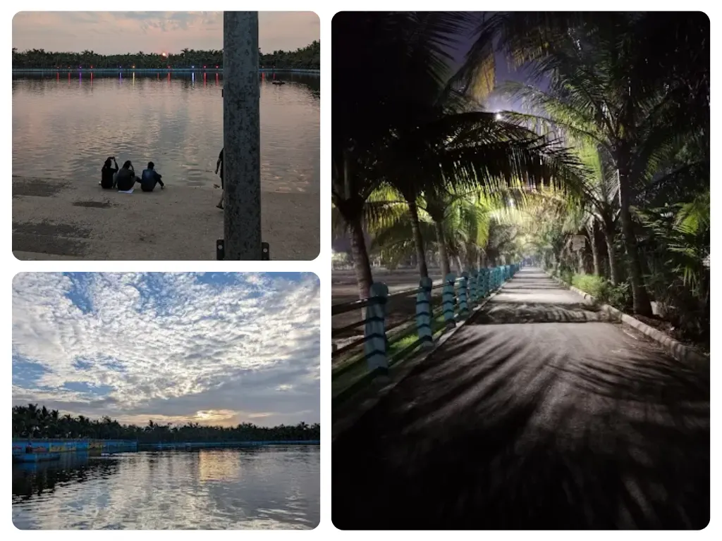
Despite being engineered, the lake offers a calm and surprisingly natural atmosphere during certain hours of the day. Early mornings bring soft light across still water, and evenings reflect the skyline against mangrove silhouettes.
For those looking for hidden places in Koparkhairane or exploring the best lakes in Navi Mumbai, this spot offers understated beauty.
Birds and Seasonal Wildlife
The lake supports pond herons, little egrets, cormorants, and other waterbirds throughout the year. During winter, occasional migratory species appear. Mangrove patches along the creek-facing edge provide nesting and resting areas.
Birdwatchers often consider it an extension of the larger Thane Creek wetland ecosystem.
Sunrise and Sunset Views
Maps will tell you coordinates, but let me tell you where it actually feels like it is. The Koparkhairne Gaon Holding Pond is situated in Sector 19A, tucked away at the eastern edge of the node. It’s the buffer zone.
It sits right between the dense, buzzing lanes of the Koparkhairne Gaothan (the original village settlement) and the newer, planned CIDCO layouts. If you look straight out, you see the thick green belt of mangroves that eventually leads into the Thane Creek. This placement is strategic, not accidental. It was designed to catch water before it catches us.
Sunrise at Koparkhairane Lake feels quiet and local. There are no tourist crowds, just joggers, elderly residents, and soft reflections on water. Sunset paints the sky in muted shades while buildings form a subtle urban backdrop.
It does not compete with iconic waterfronts. It offers something simpler and more intimate.
Photography Opportunities
Reflections, bird movement, monsoon clouds, and open sky create strong visual frames. Since construction is restricted within the waterbody zone, photographers benefit from uninterrupted lines of sight.
Local content creators frequently use the lake for minimal urban-nature compositions.
Morning Walk Experience
Maps will tell you coordinates, but let me tell you where it actually feels like it is. The Koparkhairne Gaon Holding Pond is situated in Sector 19A, tucked away at the eastern edge of the node. It’s the buffer zone.
It sits right between the dense, buzzing lanes of the Koparkhairne Gaothan (the original village settlement) and the newer, planned CIDCO layouts. If you look straight out, you see the thick green belt of mangroves that eventually leads into the Thane Creek. This placement is strategic, not accidental. It was designed to catch water before it catches us.
The internal promenade around the lake measures approximately 0.8 kilometers. The broader external sector loop measures about 2.5 kilometers if one circles the entire block around Sector 19A.
Morning hours between 5:30 AM and 7:30 AM are the most active. The lake functions not only as a jogging track but also as a daily social meeting point for residents.
Current Condition and Cleanliness Status
Koparkhairane Lake today exists in a state of transition. It is neither neglected nor fully rejuvenated. Over the years, silt accumulation, nutrient inflow from unauthorized sewage lines in older Gaothan pockets, and mangrove spread have reduced the effective holding capacity of the pond. Public discussions and court notices in previous years highlighted that nearly 30 percent of the basin area has been affected by siltation and vegetation growth.
However, 2025 and 2026 have marked a visible administrative shift. Instead of cosmetic beautification, the civic focus has moved toward structural restoration. The condition of the lake now depends less on appearance and more on hydraulic depth, oxygen levels, and flood resilience.
Maintenance by NMMC
The Navi Mumbai Municipal Corporation has allocated targeted funds under the AMRUT 2.0 scheme for holding pond rejuvenation. The approach is technical rather than decorative. Ultrasonic algae control systems are being deployed to disrupt algal growth without using harsh chemicals. Bioremediation techniques using microbial cultures are being introduced to reduce sludge and organic load naturally.
Desilting works have also been budgeted to restore the original hydraulic capacity of the detention basin. The shift indicates that authorities recognize the lake not just as a public space but as critical stormwater infrastructure.
Cleanliness and Pollution Issues

Water quality in the lake is classified as brackish and eutrophic. Because of tidal exchange with Thane Creek, the water contains saline characteristics. At the same time, nutrient-rich inflow can trigger algal blooms, especially during warmer months. When algae die and decompose, they reduce dissolved oxygen levels and create unpleasant odors.
The visible pollution is not always plastic waste. The deeper concern is biological imbalance. The 2026 strategy focuses on long-term ecological correction rather than surface cleaning drives.
Maps will tell you coordinates, but let me tell you where it actually feels like it is. The Koparkhairne Gaon Holding Pond is situated in Sector 19A, tucked away at the eastern edge of the node. It’s the buffer zone.
It sits right between the dense, buzzing lanes of the Koparkhairne Gaothan (the original village settlement) and the newer, planned CIDCO layouts. If you look straight out, you see the thick green belt of mangroves that eventually leads into the Thane Creek. This placement is strategic, not accidental. It was designed to catch water before it catches us.
Local Residents’ Feedback
Residents of Sector 19A have mixed feedback. Morning walkers appreciate the open view and accessibility, but some raise concerns about occasional odor and water color changes. At the same time, there is strong awareness that the lake prevents flooding, which increases tolerance toward temporary inconvenience.
Public sentiment has gradually shifted from blaming the lake to demanding better maintenance and industrial regulation.
Real Estate Intelligence - Sector 19A and Lake View Premium
Koparkhairane Lake significantly influences property pricing patterns in Sector 19A. Unlike purely decorative lakes in gated townships, this waterbody guarantees a permanent open view because construction inside the holding basin is restricted under environmental and planning regulations.
As of Q1 2026, residential rates in Sector 19A show stable to moderate growth.
Property Rate Snapshot
One-bedroom units in Gaothan areas range between 35 to 50 lakh depending on condition and access. Cooperative society one-bedroom units typically range from 56 to 75 lakh. Standard two-bedroom apartments fall between 1.15 crore to 1.35 crore, while lake-facing two-bedroom units can exceed 1.45 crore.
Three-bedroom configurations range between 1.80 crore and 2.40 crore depending on society quality and view orientation. Rental yields average around 4 to 5 percent annually, supported by professionals working in Mahape and Ghansoli corporate hubs.
Lake View Premium vs Risk
Lake-facing flats command a premium of approximately 10 to 15 percent over non-view units. The value proposition lies in permanent ventilation, open skyline, and reduced future construction risk. Buyers perceive the waterbody as an insurance against high-density vertical development directly opposite their balcony.
However, the premium is moderated by odor concerns. Real estate agents informally note that view-based sales conversations are more successful during morning site visits than evening ones. The lake adds value, but awareness of environmental realities keeps the pricing rational.
Socio-Cultural Role – The Visarjan Hub
Maps will tell you coordinates, but let me tell you where it actually feels like it is. The Koparkhairne Gaon Holding Pond is situated in Sector 19A, tucked away at the eastern edge of the node. It’s the buffer zone.
It sits right between the dense, buzzing lanes of the Koparkhairne Gaothan (the original village settlement) and the newer, planned CIDCO layouts. If you look straight out, you see the thick green belt of mangroves that eventually leads into the Thane Creek. This placement is strategic, not accidental. It was designed to catch water before it catches us.
The lake precinct becomes culturally significant during Ganesh Chaturthi and Navratri. Thousands of idols from Koparkhairane and nearby sectors are immersed annually.
To prevent ecological damage, NMMC has built dedicated artificial immersion tanks adjacent to the main holding pond. In 2025, the city constructed 139 artificial ponds across Navi Mumbai to encourage eco-friendly immersion practices.
Safety and Accessibility Guide
Koparkhairane Lake is accessible to the public and does not have strict entry barriers. The promenade is open during early morning and evening hours, typically from around 5 AM to 10 PM.
The lake is generally safe during monsoon for walking, though boating operations are suspended during heavy rainfall periods due to operational priorities.
Families frequently visit during evening hours. However, like any open public space, it is advisable to avoid isolated late-night visits. There are no large-scale amusement facilities at the site despite online confusion linking unrelated parks.
Best Time to Visit Koparkhairane Lake
The best time to visit Koparkhairane Lake depends on intent. For photography and calm atmosphere, early morning between 6 AM and 7 AM offers soft light and lower crowd density.
Monsoon transforms the lake into a dramatic waterbody with higher water levels and darker skies. Winter mornings provide clearer visibility and better bird activity. Peak summer afternoons are less comfortable due to heat and algal bloom probability.
Conclusion
While its primary job is to keep the city dry during the monsoon, its true value lies in the open sky and nature it provides to the residents of the Gaothan and nearby CIDCO societies. Whether you are an investor eyeing the 15% lake-view premium, a jogger hitting the 0.8 km promenade, or a photographer chasing the sunrise, this lake is the soul of Koparkhairane. It reminds us that even in a concrete city, we need a place where the water can breathe.
FAQ's
Frequently Asked Questions